The Wild & Scenic Mulberry River

canoe

Best Times to Float the Mulberry

Normally the Mulberry can be floated from late October to mid June. It generally cannot be floated during the hot summer months.

Fall floating is available only after heavy rains bring the river back up. Locally heavy rains can make the river too high to float for a day or two at a time. Normally the river will crest at Turner Bend within 8 hours of the end of the last rainfall.
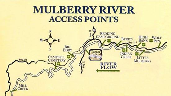
Mulberry River access points

Floating the Mulberry

The Mulberry offers about 40 miles of good floating. Depending on the water level most canoeists cover anywhere from 6 to 15 miles in a day's float. At low water levels 2 miles per hour is common. At higher water levels, 3 miles per hour is average. The following is a brief description of the various river segments.

Wolf Pen to Turner Bend

Miles: 15.7
Gradient: 16′ per mile upper half,
12′ per mile lower half


 The Mulberry is a narrow stream at Wolf Pen.  The best action begins after the confluence of the  Little Mulberry

2 miles below Wolf Pen. Big Al's Twist and Chainsaw Jungle come before High Bank Access, 2 miles below the Little Mulberry.


Next comes Jump Start, Whoop and Holler and several other rapids as the river twists around one curve after another. The action is fast and continuous. Byrd's Landing is 4.5 miles below High Bank. Troll Shoal is a fun run just above the Low Water Bridge. Stay to the right to get under the Low Water Bridge.

The stretch of river from Low Water Bridge to Turner Bend has steady action. There are few named rapids, but there are several tight curves that will wreck an unwary canoe at high water. Redding Campground is on the right 2.7 miles below Low Water Bridge. Two miles below Redding is the Sacroiliac Rapid where a large boulder sits on the outside of a right hand curve. Turner Bend is 1.5 miles downstream.

Turner Bend to Campbell Cemetery  

Miles: 10.6
Gradient: 11′ per mile

The river takes on more of a "pool and drop" characteristic here. Watch for fallen trees in the second mile below Turner Bend as the bank is very erodible here. Rocking Horse/Picture Book come back to back midway in this run.

Big waves and good times here!

Several more wide shoals lead you up to a big field on the right just after the river turns west. Milton Ford is 1.9 miles before Campbell Cemetery. A half-mile before Campbell is Hamm Falls, one of the best rapids on the river. Be ready for this one! Rock steps on the right mark Campbell Cemetery.

Campbell Cemetery to Mill Creek 

Miles: 12.7
Gradient: 11′ per mile

This is a beautiful and remote stretch of river. The pools are long, but the rapids are big. Hell Roaring Falls, 3 miles below Campbell, is a thrill. The middle part of this run is slow but the action picks up near the end as the river breaks out of the mountains. Mill Creek access is 1/2 mile below a large cable that crosses over a long pool in the river.

River Levels for Kayaking, Canoeing & Rafting

The Mulberry River gauge at the Turner Bend landing measures the river level in 2/10s increments. The river difficulty as it relates to that gauge is described as follows:

Below 1.2 – Very low. Lots of dragging. Kayaks only.
1.3 – 1.4 – Low but floatable for canoes and kayaks. Some dragging unavoidable. Keep your trip short.

1.5 – 1.7 – Mild flow that is OK for  beginners.  You shouldn't drag unless you  pick the wrong path. 
1.8 1.9 – Good low water floating. Too low for rafts.
2.0 – 2.1 Mild whitewater with lots of rock dodging. Enough water for a short raft trip.
2.2 - 2.4 - Challenging for beginners because of the exposed rocks.  Good fun level.
2.5 - 2.9 - The pools are not flowing fast, but many rapids are
 at their best in this range. Not a casual picnic float.

3.0 -3.6 – Prime whitewater. Most rocks are covered. Big waves that can swamp canoes. Great rafting.
3.7 – 4.0 – Big fast water with almost no pools. All the rocks are covered at this level. Powerful current.
4.1 – 4.5 - You must know the river and know w
hat you are doing. Kayak and raft rentals only if we are assured that you are skilled.
4.6 – 5.0 – Too much water for rental. Too high to get under the Low Water Bridge. The river exceeds it's banks and flows through the trees.

Floods can alter the river channel and cause minor changes in the gauge readings compared to past experience.
This is a beautiful and  remote stretch or the river.  The pools are long, but the rapids are big.  Hell Roaring Falls, 3 miles below Campbell,  is a thrill. The middle part of this run is slow but the action picks up near the end as the river breaks out of the mountains.   Mill Creek access is 1/2 mile below a large cable that crosses over a long pool in the river. 

high bank